A dust plume that has been traveling across the Atlantic may later spread as far as Texas and Georgia as a weather system breaks it apart.
A cloud of Saharan dust over the Caribbean reached South Florida on Wednesday evening and was expected to spread across the state on Thursday, bringing drier weather after several days of heavy rain.
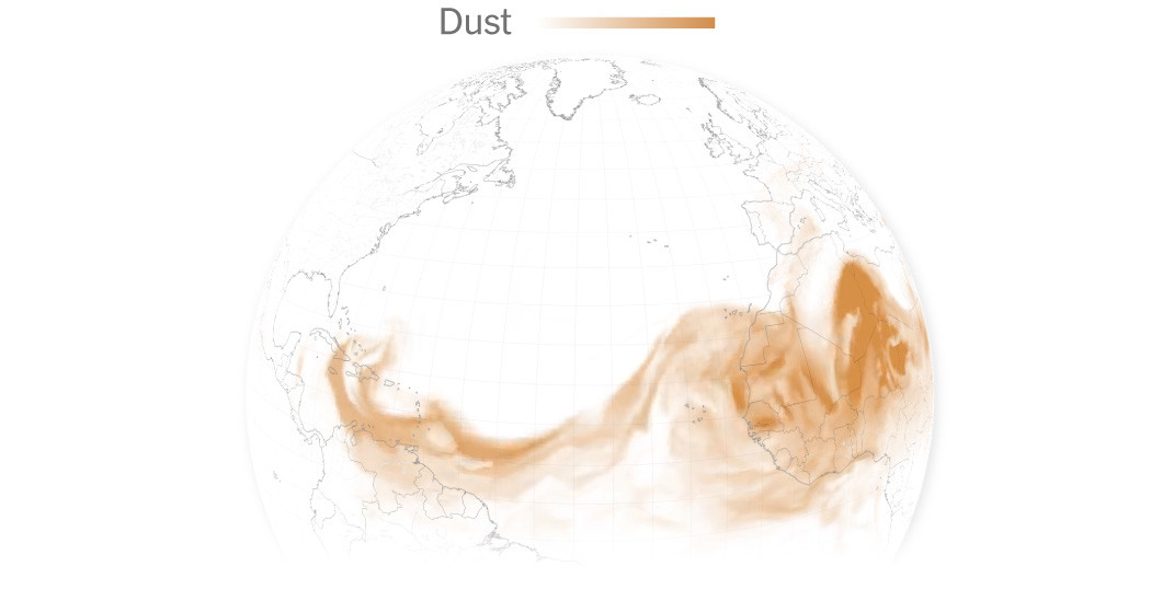
The dry air and dust, known as the Saharan Air Layer, have traveled more than 5,000 miles from North Africa as a discernible mass that even someone without a degree in meteorology could identify on satellite. The plume is expected to fall apart in coming days, with some dust moving into the southeast Atlantic Ocean, potentially grazing Georgia and South Carolina, and some scattering across the Gulf, likely filtering into as far as Texas by Friday and into the weekend.
“We’ll see that ramp up over South Florida in the next 18 to 24 hours,” said George Rizzuto, a meteorologist with the National Weather Service office in Miami. “It will linger through the end of the week.”
The Saharan Air Layer forms when winds lift sand and minerals from the Sahara in North Africa into the atmosphere. It then gets whisked away by a strong wind current, which sometimes pushes it north into Europe, but more commonly carries it west across the Atlantic Ocean. It usually reaches the Caribbean and the Gulf Coast region several times a year.
The dust events occur year-round but are most common from about mid-May into August, usually peaking mid-June to July.
Earlier forecasts had indicated that a cloud of dust would travel from the Caribbean into the Gulf Coast region, but on Wednesday a weather system off the coast of Florida appeared likely to disrupt and diffuse the dust plume.


![Enjoy the [Road] Show Travel Mug with Handle, 14ozEnjoy the [Road] Show Travel Mug with Handle, 14oz](https://georgemagazine.com/wp-content/uploads/2024/08/479070202831754764_2048-300x300.jpeg)